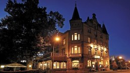
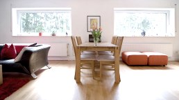
The apartment is located in the guest house at the Viehmarkt, in the crime capital Hillesheim, on the second floor of the over 100 year old house, and is accessible by stairs. It is 74 m² in size and has 2 bedrooms, 1 living room, 1 kitchen, 1 bathroom. The more spacious bedroom has a double bed and a 3-door closet and a suitcase storage. Here, in the bedroom, there is also the spatial possibility to place the children's travel crib. The smaller bedroom is equipped with a pull-out bunk bed for adults and an office table + chair. Both rooms are accessible from the guest hallway. The living room invites you, with its spacious, pull-out couch, just to put your feet up and let the evening end with good music or the TV. If you look out of the living room windows, you will have an excellent view of the directly adjacent cattle market, where every Thursday there is a lively hustle and bustle (market day). In addition, on the opposite side of the street is the Eifel- Alm, an experience gastronomy. All three rooms are additionally equipped with external shutters, which ensure an excellent darkening of the rooms. The spacious kitchen offers a fantastic view of the former city wall from the 13th century as well as a view of the Bolsdorfer Tälchen, with its 1.5 km long barefoot path and its 22 stations as well as numerous hiking trails. Moreover, looking out of the kitchen window, you can enjoy dreamlike sunsets. The spacious kitchen table can seat 6 people + a child's chair, so the whole family can comfortably sit here and play board games after dinner. The bathroom is equipped with a bathtub, WC, WB, hairdryer and a potty. A changing mat is also available, as well as a baby bath and children's dishes in double quantity. A washing machine and a dryer are located in the small utility room of the guest apartment and can be used free of charge. The tourist tax of € 1.50 per person is included as well as 1 bottle of natural wine per person and a bottle of wine on arrival and the energy costs. Bed linen and one large + one small towel per person (for use during the stay) are charged at € 15,- per person. The price for the final cleaning is € 80,-/25,-.The apartment was renovated in 2022 and except for the kitchen with its appliances, the furnishings are new. Nevertheless, the charm of the old house has been preserved, which you can already feel when you enter the house.The access to the guest apartment is via the courtyard side (fire department access). Here you have a garage space at your disposal. There is also a small seating area in the courtyard. If you go down the adjacent stairs, you will immediately reach the elementary school on the left. In the elementary school there is a small indoor swimming pool, which is open to the public in the afternoon hours. So: pack your "swimming trunks". The exact opening hours you can call: Tel. 06591 4538 inquire. Further indoor swimming pools are in Gerolstein (approx. 9 km) and Jünckerath (approx. 13 km) away.
Details ansehen 


